Mesopotamia
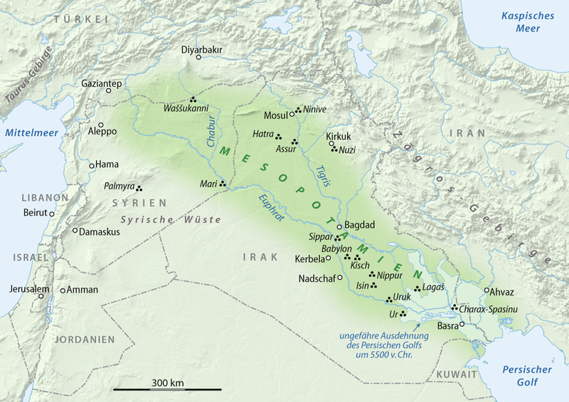
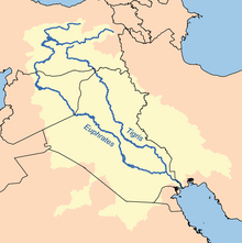
Mesopotamia (from the Ancient Greek: Μεσοποταμία: "[land] between rivers"; Arabic: بلاد الرافدين (bilād al-rāfidayn); Syriac: ܒܝܬ ܢܗܪܝܢ(Beth Nahrain): "land of rivers") is a name for the area of the Tigris–Euphrates river system, corresponding to modern-day Iraq, the northeastern section of Syria and to a much lesser extent southeastern Turkey, smaller parts of southwestern Iran and Kuwait.
Widely considered to be the cradle of civilization in the West, Bronze Age Mesopotamia included Sumer and the Akkadian,Babylonian, and Assyrian empires, all native to the territory of modern-day Iraq. In the Iron Age, it was controlled by the Neo-Assyrianand Neo-Babylonian empires. The indigenous Sumerians and Akkadians (including Assyrians and Babylonians) dominated Mesopotamia from the beginning of written history (c. 3100 BC) to the fall of Babylon in 539 BC, when it was conquered by theAchaemenid Empire. It fell to Alexander the Great in 332 BC, and after his death, it became part of the Greek Seleucid Empire.
Around 150 BC, Mesopotamia was under the control of the Parthians. Mesopotamia became a battleground between the Romans and Parthians, with parts of Mesopotamia coming under ephemeral Roman control. In AD 226, it fell to the Sassanid Persians and remained under Persian rule until the 7th-century Arab Islamic conquest of the Sassanid Empire. A number of primarily neo Assyrian and Christian native Mesopotamian states existed between the 1st century BC and 3rd century AD, including Adiabene, Osroene, andHatra.
Etymology
The regional toponym Mesopotamia comes from the ancient Greek root words μέσος (meso) "middle" and ποταμός (potamia) "river" and literally means "(Land) between rivers". It is used throughout the Greek Septuagint (ca. 250 BC) to translate the Hebrew equivalent Naharaim. An even earlier Greek usage of the name Mesopotamia is evident from the Anabasis Alexandri, which was written in the late 2nd century AD, but specifically refers to sources from the time of Alexander the Great. In the Anabasis, Mesopotamia was used to designate the land east of the Euphrates in north Syria. The Aramaicterm biritum/birit narim corresponded to a similar geographical concept.[1] Later, the term Mesopotamia was more generally applied to all the lands between the Euphrates and the Tigris, thereby incorporating not only parts of Syria but also almost all of Iraq and southeastern Turkey.[2] The neighbouring steppes to the west of the Euphrates and the western part of the Zagros Mountains are also often included under the wider term Mesopotamia.[3][4][5] A further distinction is usually made between Upper or Northern Mesopotamia and Lower or Southern Mesopotamia.[6] Upper Mesopotamia, also known as the Jezirah, is the area between the Euphrates and the Tigris from their sources down to Baghdad.[3] Lower Mesopotamia consists of southern Iraq, Kuwait and parts of western Iran.[7][8][9] In modern academic usage, the term Mesopotamia often also has a chronological connotation. It is usually used to designate the area until the Muslim conquests, with names like Syria, Jezirah, and Iraq being used to describe the region after that date.[2][10] It has been argued that these later euphemisms are Eurocentric terms attributed to the region in the midst of various 19th-century Western encroachments.
Geography
Mesopotamia encompasses the land between the Euphrates and Tigris rivers, both of which have their headwaters in the mountains of Armenia in modern-day Turkey. Both rivers are fed by numerous tributaries, and the entire river system drains a vast mountainous region. Overland routes in Mesopotamia usually follow the Euphrates because the banks of the Tigris are frequently steep and difficult. The climate of the region is semi-arid with a vast desert expanse in the north which gives way to a 15,000 square kilometres (5,800 sq mi) region of marshes, lagoons, mud flats, and reed banks in the south. In the extreme south, the Euphrates and the Tigris unite and empty into the Persian Gulf.
The arid environment which ranges from the northern areas of rain-fed agriculture to the south where irrigation of agriculture is essential if a surplus energy returned on energy invested (EROEI) is to be obtained. This irrigation is aided by a high water table and by melting snows from the high peaks of the Zagros Mountains and from the Armenian cordillera, the source of the Tigris and Euphrates Rivers that give the region its name. The usefulness of irrigation depends upon the ability to mobilize sufficient labor for the construction and maintenance of canals, and this, from the earliest period, has assisted the development of urban settlements and centralized systems of political authority.
Agriculture throughout the region has been supplemented by nomadic pastoralism, where tent-dwelling nomads herded sheep and goats (and later camels) from the river pastures in the dry summer months, out into seasonal grazing lands on the desert fringe in the wet winter season. The area is generally lacking in building stone, precious metals and timber, and so historically has relied upon long-distance trade of agricultural products to secure these items from outlying areas. In the marshlands to the south of the area, a complex water-borne fishing culture has existed since prehistoric times, and has added to the cultural mix.
Periodic breakdowns in the cultural system have occurred for a number of reasons. The demands for labor has from time to time led to population increases that push the limits of the ecological carrying capacity, and should a period of climatic instability ensue, collapsing central government and declining populations can occur. Alternatively, military vulnerability to invasion from marginal hill tribes or nomadic pastoralists has led to periods of trade collapse and neglect of irrigation systems. Equally, centripetal tendencies amongst city states has meant that central authority over the whole region, when imposed, has tended to be ephemeral, and localism has fragmented power into tribal or smaller regional units.[12] These trends have continued to the present day in Iraq.
History
The pre-history of the Ancient Near East begins in the Lower Paleolithic period, but writing began with a pictographic script in the Uruk IV period (ca. 4th millennium BC), and the documented record of actual historical events — and the ancient history of lower Mesopotamia — commence in the mid-third millennium BC with cuneiform records of early dynastic kings, and ends with either the arrival of the Achaemenid Empire in the late 6th century BC, or with the Arab Islamic conquest of Mesopotamia and the establishment of the Caliphate in the late 7th century AD, from which point the region came to be known as Iraq. During this period Mesopotamia housed some of the world's most ancient highly developed and socially complex states. The region was one of the four riverine civilizations where writing was invented, along with the Nile valley in Egypt, the Indus Valleyin the Indian subcontinent, and Yellow River valley in China. Mesopotamia housed historically important cities such as Uruk, Nippur, Nineveh,Assur and Babylon, as well as major territorial states such as the city of Eridu, the Akkadian kingdom, the Third Dynasty of Ur, and the variousAssyrian empires. Some of the important historical Mesopotamian leaders were Ur-Nammu (king of Ur), Sargon (who established the Akkadian Empire), Hammurabi (who established the Old Babylonian state), Ashur-uballit II and Tiglath-Pileser I (who established the Assyrian Empires).
Periodization
- Pre- and protohistory
- Pre-Pottery Neolithic A (10,000–8700 BC)
- Pre-Pottery Neolithic B (8700–6800)
- Hassuna (~6000 bc–? BC), Samarra (~5700 BC–4900 BC) and Halaf (~6000 BC–5300 BC) cultures
- Ubaid period (~5900–4400 BC)
- Uruk period (~4400–3100 BC)
- Jemdet Nasr period (~3100–2900 BC)[13]
- Early Bronze Age
- Early Dynastic period (~2900–2350 BC)
- Akkadian Empire (~2350–2100 BC)
- Ur III period (2112–2004 BC)
- Early Assyrian kingdom (24th to 18th century BC)
- Middle Bronze Age
- Early Babylonia (19th to 18th century BC)
- First Babylonian Dynasty (18th to 17th century BC)
- collapse: Minoan Eruption (c. 1620 BC)
- Late Bronze Age
- Middle Assyrian period (16th to 11th century BC)
- Assyrian Empire (c. 1365 BC–1076 BC)
- Kassite dynasty in Babylon, (c. 1595 BC–1155 BC)
- collapse: Bronze Age collapse (12th to 11th century BC)
- Iron Age
- Neo-Hittite or Syro-Hittite regional states (11th to 7th century BC)
- Neo-Assyrian Empire (10th to 7th century BC)
- Neo-Babylonian Empire (7th to 6th century BC)
- Classical Antiquity
- Persian Babylonia, Achaemenid Assyria (6th to 4th century BC)
- Seleucid Mesopotamia (4th to 3rd century BC)
- Parthian Babylonia (3rd century BC to 3rd century AD)
- Osroene (2nd century BC to 3rd century AD)
- Adiabene (1st to 2nd century AD)
- Hatra (1st to 2nd century AD)
- Roman Mesopotamia, Roman Assyria (2nd century AD)
- Late Antiquity
- Persian Mesopotamia, Persian Asuristan (Assyria) (3rd to 7th century AD)
- Arab Muslim conquest of Mesopotamia (mid-7th century AD)
Language and writing
The earliest language written in Mesopotamia was Sumerian, an agglutinative language isolate. Along with Sumerian, Semitic dialects were also spoken in early Mesopotamia. Subartuan[14] a language of the Zagros, perhaps related to the Hurro-Urartuan language family is attested in personal names, rivers and mountains and in various crafts. Akkadian, came to be the dominant language during the Akkadian Empire and the Assyrian empires, but Sumerian was retained for administration, religious, literary, and scientific purposes. Different varieties of Akkadian were used until the end of the Neo-Babylonian period. Aramaic, which had already become common in Mesopotamia, then became the official provincial administration language of first theNeo Assyrian Empire, and then the Achaemenid Persian Empire. Akkadian fell into disuse, but both it and Sumerian were still used in temples for some centuries. The last Akkadian texts date from the late 1st century AD.
Early in Mesopotamia's history (around the mid-4th millennium BC) cuneiform script was invented for the Sumerian language. Cuneiform literally means "wedge-shaped", due to the triangular tip of the stylus used for impressing signs on wet clay. The standardized form of each cuneiform sign appears to have been developed from pictograms. The earliest texts (7 archaic tablets) come from the E Temple dedicated to the goddess Inanna at Uruk, from a building labeled as Temple C by its excavators.
The early logographic system of cuneiform script took many years to master. Thus, only a limited number of individuals were hired as scribes to be trained in its use. It was not until the widespread use of a syllabic script was adopted under Sargon's rule[citation needed] that significant portions of Mesopotamian population became literate. Massive archives of texts were recovered from the archaeological contexts of Old Babylonian scribal schools, through which literacy was disseminated.
During the third millennium BC, there developed a very intimate cultural symbiosis between the Sumerian and the Akkadian language users, which included widespread bilingualism.[15] The influence of Sumerian on Akkadian (and vice versa) is evident in all areas, from lexical borrowing on a massive scale, to syntactic, morphological, and phonological convergence.[15] This has prompted scholars to refer to Sumerian and Akkadian in the third millennium as a sprachbund.[15] Akkadian gradually replaced Sumerian as the spoken language of Mesopotamia somewhere around the turn of the 3rd and the 2nd millennium BC (the exact dating being a matter of debate),[16] but Sumerian continued to be used as a sacred, ceremonial, literary, and scientific language in Mesopotamia until the 1st century AD.
Literature
Libraries were extant in towns and temples during the Babylonian Empire. An old Sumerian proverb averred that "he who would excel in the school of the scribes must rise with the dawn." Women as well as men learned to read and write,[17] and for the Semitic Babylonians, this involved knowledge of the extinct Sumerian language, and a complicated and extensive syllabary.
A considerable amount of Babylonian literature was translated from Sumerian originals, and the language of religion and law long continued to be the old agglutinative language of Sumer. Vocabularies, grammars, and interlinear translations were compiled for the use of students, as well as commentaries on the older texts and explanations of obscure words and phrases. The characters of the syllabary were all arranged and named, and elaborate lists were drawn up.
Many Babylonian literary works are still studied today. One of the most famous of these was the Epic of Gilgamesh, in twelve books, translated from the original Sumerian by a certain Sin-liqe-unninni, and arranged upon an astronomical principle. Each division contains the story of a single adventure in the career of Gilgamesh. The whole story is a composite product, although it is probable that some of the stories are artificially attached to the central figure.
Science and technology
Mathematics
Main articles: Babylonian mathematics and Babylonian calendar
Mesopotamian mathematics and science was based on a sexagesimal (base 60) numeral system. This is the source of the 60-minute hour, the 24-hour day, and the 360-degree circle. The Sumerian calendar was based on the seven-day week. This form of mathematics was instrumental in early map-making. The Babylonians also had theorems on how to measure the area of several shapes and solids. They measured the circumference of a circle as three times the diameter and the area as one-twelfth the square of the circumference, which would be correct if pi were fixed at 3. The volume of a cylinder was taken as the product of the area of the base and the height; however, the volume of the frustum of a cone or a square pyramid was incorrectly taken as the product of the height and half the sum of the bases. Also, there was a recent discovery in which a tablet used pi as 25/8 (3.125 instead of 3.14159~). The Babylonians are also known for the Babylonian mile, which was a measure of distance equal to about seven modern miles (11 km). This measurement for distances eventually was converted to a time-mile used for measuring the travel of the Sun, therefore, representing time.[18]
Astronomy
Main article: Babylonian astronomy
From Sumerian times, temple priesthoods had attempted to associate current events with certain positions of the planets and stars. This continued to Assyrian times when Limmu lists were created as a year by year association of events with planetary positions, which, when they have survived to the present day, allow accurate associations of relative with absolute dating for establishing the history of Mesopotamia.
The Babylonian astronomers were very adept at mathematics and could predict eclipses and solstices. Scholars thought that everything had some purpose in astronomy. Most of these related to religion and omens. Mesopotamian astronomers worked out a 12-month calendar based on the cycles of the moon. They divided the year into two seasons: summer and winter. The origins of astronomy as well as astrology date from this time.
During the 8th and 7th centuries BC, Babylonian astronomers developed a new approach to astronomy. They began studying philosophy dealing with the ideal nature of the early universe and began employing an internal logic within their predictive planetary systems. This was an important contribution to astronomy and the philosophy of science and some scholars have thus referred to this new approach as the first scientific revolution.[19] This new approach to astronomy was adopted and further developed in Greek and Hellenistic astronomy.
In Seleucid and Parthian times, the astronomical reports were thoroughly scientific; how much earlier their advanced knowledge and methods were developed is uncertain. The Babylonian development of methods for predicting the motions of the planets is considered to be a major episode in the history of astronomy.
The only Greek Babylonian astronomer known to have supported a heliocentric model of planetary motion was Seleucus of Seleucia (b. 190 BC).[20][21][22] Seleucus is known from the writings ofPlutarch. He supported Aristarchus of Samos' heliocentric theory where the Earth rotated around its own axis which in turn revolved around the Sun. According to Plutarch, Seleucus even proved the heliocentric system, but it is not known what arguments he used (except that he correctly theorized on tides as a result of Moon's attraction).
Babylonian astronomy served as the basis for much of Greek, classical Indian, Sassanian, Byzantine, Syrian, medieval Islamic, Central Asian, and Western European astronomy.[23]
Medicine
The oldest Babylonian texts on medicine date back to the Old Babylonian period in the first half of the 2nd millennium BC. The most extensive Babylonian medical text, however, is the Diagnostic Handbook written by the ummânū, or chief scholar, Esagil-kin-apli of Borsippa,[24] during the reign of the Babylonian king Adad-apla-iddina (1069-1046 BC).[25]
Along with contemporary Egyptian medicine, the Babylonians introduced the concepts of diagnosis, prognosis, physical examination, and prescriptions. In addition, the Diagnostic Handbookintroduced the methods of therapy and aetiology and the use of empiricism, logic, and rationality in diagnosis, prognosis and therapy. The text contains a list of medical symptoms and often detailed empirical observations along with logical rules used in combining observed symptoms on the body of a patient with its diagnosis and prognosis.[26]
The symptoms and diseases of a patient were treated through therapeutic means such as bandages, creams and pills. If a patient could not be cured physically, the Babylonian physicians often relied on exorcism to cleanse the patient from any curses. Esagil-kin-apli's Diagnostic Handbook was based on a logical set of axioms and assumptions, including the modern view that through the examination and inspection of the symptoms of a patient, it is possible to determine the patient's disease, its aetiology, its future development, and the chances of the patient's recovery.[24]
Esagil-kin-apli discovered a variety of illnesses and diseases and described their symptoms in his Diagnostic Handbook. These include the symptoms for many varieties of epilepsy and relatedailments along with their diagnosis and prognosis.[27]
Technology
Mesopotamian people invented many technologies including metal and copper-working, glass and lamp making, textile weaving, flood control, water storage, and irrigation. They were also one of the first Bronze age people in the world. They developed from copper, bronze, and gold on to iron. Palaces were decorated with hundreds of kilograms of these very expensive metals. Also, copper, bronze, and iron were used for armor as well as for different weapons such as swords, daggers, spears, and maces.
According to a recent hypothesis, the Archimedes screw may have been used by Sennacherib, King of Assyria, for the water systems at the Hanging Gardens of Babylon and Nineveh in the 7th century BC, although mainstream scholarship holds it to be a Greek invention of later times.[28] Later during the Parthian or Sassanid periods, the Baghdad Battery, which may have been the world's first battery, was created in Mesopotamia.[29]
Religion and philosophy
Mesopotamian religion was the first to be recorded. Mesopotamians believed that the world was a flat disc[citation needed], surrounded by a huge, holed space, and above that, heaven. They also believed that water was everywhere, the top, bottom and sides, and that the universe was born from this enormous sea. In addition, Mesopotamian religion was polytheistic.
Although the beliefs described above were held in common among Mesopotamians, there were also regional variations. The Sumerian word for universe is an-ki, which refers to the god An and the goddess Ki[citation needed]. Their son was Enlil, the air god. They believed that Enlil was the most powerful god. He was the chief god of the Pantheon, equivalent to the Greek god Zeus and the Roman god Jupiter. The Sumerians also posed philosophical questions, such as: Who are we?, Where are we?, How did we get here?.[citation needed] They attributed answers to these questions to explanations provided by their gods.

Philosophy
The origins of philosophy can be traced back to early Mesopotamian wisdom, which embodied certain philosophies of life, particularly ethics, in the forms of dialectic, dialogs, epic poetry, folklore, hymns, lyrics, prose works, and proverbs. Babylonian reasoning and rationality developed beyond empirical observation.[30]
The earliest form of logic was developed by the Babylonians, notably in the rigorous nonergodic nature of their social systems. Babylonian thought was axiomatic and is comparable to the "ordinary logic" described by John Maynard Keynes. Babylonian thought was also based on anopen-systems ontology which is compatible with ergodic axioms.[31] Logic was employed to some extent in Babylonian astronomy and medicine.
Babylonian thought had a considerable influence on early Greek and Hellenistic philosophy. In particular, the Babylonian text Dialogue of Pessimism contains similarities to the agonistic thought of the sophists, the Heraclitean doctrine of contrasts, and the dialectic and dialogs ofPlato, as well as a precursor to the maieutic method of Socrates.[32] The Ionian philosopher Thales was influenced by Babylonian cosmological ideas.
Culture
Festivals
Ancient Mesopotamians had ceremonies each month. The theme of the rituals and festivals for each month was determined by at least six important factors:
- The Lunar phase (a waxing moon meant abundance and growth, while a waning moon was associated with decline, conservation, and festivals of the Underworld)
- The phase of the annual agricultural cycle
- Equinoxes and solstices
- The local mythos and its divine Patrons
- The success of the reigning Monarch
- Commemoration of specific historical events (founding, military victories, temple holidays, etc.)
Music
Main article: Music of Mesopotamia
Some songs were written for the gods but many were written to describe important events. Although music and songs amused kings, they were also enjoyed by ordinary people who liked to sing and dance in their homes or in the marketplaces. Songs were sung to children who passed them on to their children. Thus songs were passed on through many generations as an oral tradition until writing was more universal. These songs provided a means of passing on through the centuries highly important information about historical events.
The Oud (Arabic:العود) is a small, stringed musical instrument used by the Mesopotamians. The oldest pictorial record of the Oud dates back to the Uruk period in Southern Mesopotamia over 5000 years ago. It is on a cylinder seal currently housed at the British Museum and acquired by Dr. Dominique Collon. The image depicts a female crouching with her instruments upon a boat, playing right-handed. This instrument appears hundreds of times throughout Mesopotamian history and again in ancient Egypt from the 18th dynasty onwards in long- and short-neck varieties. The oud is regarded as a precursor to the European lute. Its name is derived from the Arabic word العود al-‘ūd 'the wood', which is probably the name of the tree from which the oud was made. (The Arabic name, with the definite article, is the source of the word 'lute'.)

Games
Hunting was popular among Assyrian kings. Boxing and wrestling feature frequently in art, and some form of polo was probably popular, with men sitting on the shoulders of other men rather than on horses.[33] They also played majore, a game similar to the sport rugby, but played with a ball made of wood. They also played a board game similar to senet and backgammon, now known as the "Royal Game of Ur."
Family life
Mesopotamia, as shown by successive law codes, those of Urukagina, Lipit Ishtar and Hammurabi, across its history became more and more apatriarchal society, one in which the men were far more powerful than the women. For example, during the earliest Sumerian period, the "en", or high priest of male gods was originally a woman, that of female goddesses, a man. Thorkild Jacobsen, as well as many others, has suggested that early Mesopotamian society was ruled by a "council of elders" in which men and women were equally represented, but that over time, as the status of women fell, that of men increased. As for schooling, only royal offspring and sons of the rich and professionals, such as scribes, physicians, temple administrators, went to school. Most boys were taught their father's trade or were apprenticed out to learn a trade.[34] Girls had to stay home with their mothers to learn housekeeping and cooking, and to look after the younger children. Some children would help with crushing grain or cleaning birds. Unusual for that time in history, women in Mesopotamia had rights. They could own property and, if they had good reason, get a divorce.
Burials
Hundreds of graves have been excavated in parts of Mesopotamia, revealing information about Mesopotamian burial habits. In the city of Ur, most people were buried in family graves under their houses, along with some possessions. A few have been found wrapped in mats and carpets. Deceased children were put in big "jars" which were placed in the family chapel. Other remains have been found buried in common city graveyards. 17 graves have been found with very precious objects in them. It is assumed that these were royal graves. Rich of various periods, have been discovered to have sought burial in Bahrein, identified with Sumerian Dilmun.[35]
Economy and agriculture
Irrigated agriculture spread southwards from the Zagros foothills with the Samara and Hadji Muhammed culture, from about 5,000 BC.[36] Sumerian temples functioned as banks and developed the first large-scale system of loans and credit, but the Babylonians developed the earliest system of commercial banking. It was comparable in some ways to modern post-Keynesian economics, but with a more "anything goes" approach.[31]
In the early period down to Ur III temples owned up to one third of the available land, declining over time as royal and other private holdings increased in frequency. The word Ensi was used to describe the official who organized the work of all facets of temple agriculture. Villeins are known to have worked most frequently within agriculture, especially in the grounds of temples or palaces.[37]
The geography of southern Mesopotamia is such that agriculture is possible only with irrigation and good drainage, a fact which has had a profound effect on the evolution of early Mesopotamian civilization. The need for irrigation led the Sumerians, and later the Akkadians, to build their cities along the Tigris and Euphrates and the branches of these rivers. Major cities, such as Ur and Uruk, took root on tributaries of the Euphrates, while others, notably Lagash, were built on branches of the Tigris. The rivers provided the further benefits of fish (used both for food and fertilizer), reeds, and clay (for building materials). With irrigation, the food supply in Mesopotamia was compabale to the Canadian prairies.[38] The Tigris and Euphrates River valleys form the northeastern portion of the Fertile Crescent, which also included the Jordan River valley and that of the Nile. Although land nearer to the rivers was fertile and good for crops, portions of land farther from the water were dry and largely uninhabitable. This is why the development of irrigation was very important for settlers of Mesopotamia. Other Mesopotamian innovations include the control of water by dams and the use of aqueducts. Early settlers of fertile land in Mesopotamia used wooden plows to soften the soil before planting crops such as barley, onions, grapes, turnips, and apples. Mesopotamian settlers were some of the first people to make beer and wine. As a result of the skill involved in farming in the Mesopotamian, farmers did not depend on slaves to complete farm work for them, but there were some exceptions. There were too many risks involved to make slavery practical (i.e. the escape/mutiny of the slave). Although the rivers sustained life, they also destroyed it by frequent floods that ravaged entire cities. The unpredictable Mesopotamian weather was often hard on farmers; crops were often ruined so backup sources of food such as cows and lambs were also kept. Over time the southernmost parts of Sumerian Mesopotamia suffered from increased salinity of the soils, leading to a slow urban decline and a centring of power in Akkad, further north.
Government
The geography of Mesopotamia had a profound impact on the political development of the region. Among the rivers and streams, the Sumerian people built the first cities along with irrigation canals which were separated by vast stretches of open desert or swamp where nomadic tribes roamed. Communication among the isolated cities was difficult and, at times, dangerous. Thus, each Sumerian city became a city-state, independent of the others and protective of its independence. At times one city would try to conquer and unify the region, but such efforts were resisted and failed for centuries. As a result, the political history of Sumer is one of almost constant warfare. Eventually Sumer was unified by Eannatum, but the unification was tenuous and failed to last as the Akkadians conquered Sumeria in 2331 BC only a generation later. The Akkadian Empire was the first successful empire to last beyond a generation and see the peaceful succession of kings. The empire was relatively short-lived, as the Babylonians conquered them within only a few generations.
Kings
The Mesopotamians believed their kings and queens were descended from the City of Gods, but, unlike the ancient Egyptians, they never believed their kings were real gods.[39] Most kings named themselves “king of the universe” or “great king”. Another common name was “shepherd”, as kings had to look after their people.
Power
When Assyria grew into an empire, it was divided into smaller parts, called provinces. Each of these were named after their main cities, like Nineveh, Samaria, Damascus, and Arpad. They all had their own governor who had to make sure everyone paid their taxes. Governors also had to call up soldiers to war and supply workers when a temple was built. He was also responsible for enforcing the laws. In this way, it was easier to keep control of a large empire. Although Babylon was quite a small state in the Sumerian, it grew tremendously throughout the time ofHammurabi's rule. He was known as “the law maker”, and soon Babylon became one of the main cities in Mesopotamia. It was later called Babylonia, which meant "the gateway of the gods." It also became one of history's greatest centers of learning.
Warfare
With the end of the Uruk phase, walled cities grew and many isolated Ubaid villages were abandoned indicating a rise in communal violence. An early king Lugalbanda was supposed to have built the white walls around the city. As city-states began to grow, their spheres of influence overlapped, creating arguments between other city-states, especially over land and canals. These arguments were recorded in tablets several hundreds of years before any major war—the first recording of a war occurred around 3200 BC but was not common until about 2500 BC. AnEarly Dynastic II king (Ensi) of Uruk in Sumer, Gilgamesh (c. 2,600 BC), was commended for military exploits against Humbaba guardian of the Cedar Mountain, and was later celebrated in many later poems and songs in which he was claimed to be two-thirds god and only one-third human. The later Stele of the Vultures at the end of the Early Dynastic III period (2600–2350 BC), commemorating the victory of Eannatum ofLagash over the neighbouring rival city of Umma is the oldest monument in the world that celebrates a massacre.[40] From this point forwards, warfare was incorporated into the Mesopotamian political system. At times a neutral city may act as an arbitrator for the two rival cities. This helped to form unions between cities, leading to regional states.[39] When empires were created, they went to war more with foreign countries. King Sargon, for example, conquered all the cities of Sumer, some cities in Mari, and then went to war with northern Syria. Many Assyrian and Babylonian palace walls were decorated with the pictures of the successful fights and the enemy either desperately escaping or hiding amongst reeds.

Laws
City-states of Mesopotamia created the first law codes, drawn from legal precedence and decisions made by Kings. The codes of Urukaginaand Lipit Ishtar have been found. The most renowned of these was that of Hammurabi, as mentioned above, who was posthumously famous for his set of laws, the Code of Hammurabi (created c. 1780 BC), which is one of the earliest sets of laws found and one of the best preserved examples of this type of document from ancient Mesopotamia. He codified over 200 laws for Mesopotamia.
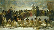
Art
The art of Mesopotamia rivalled that of Ancient Egypt as the most grand, sophisticated and elaborate in western Eurasia from the 4th millennium BC until the Persian Achaemenid Empire conquered the region in the 6th century BC. The main emphasis was on various, fortunately very durable, forms of sculpture in stone and clay; little painting has survived, but what has suggests that painting was mainly used for geometrical and plant-based decorative schemes, though most sculpture was also painted.
The Protoliterate period, dominated by Uruk, saw the production of sophisticated works like the Warka Vase and cylinder seals. The Guennol Lioness is an outstanding small limestone figure from Elam of about 3000–2800 BC, part man and part lion.[41] A little later there are a number of figures of large-eyed priests and worshippers, mostly in alabaster and up to a foot high, who attended temple cult images of the deity, but very few of these have survived.[42] Sculptures from the Sumerian and Akkadian period generally had large, staring eyes, and long beards on the men. Many masterpieces have also been found at the Royal Cemetery at Ur (c. 2650 BC), including the two figures of a Ram in a Thicket, the Copper Bull and a bull's head on one of the Lyres of Ur.[43]
From the many subsequent periods before the ascendency of the Neo-Assyrian Empire Mesopotamian art survives in a number of forms: cylinder seals, relatively small figures in the round, and reliefs of various sizes, including cheap plaques of moulded pottery for the home, some religious and some apparently not.[44] The Burney Relief is an unusual elaborate and relatively large (20 x 15 inches) terracotta plaque of a naked winged goddess with the feet of a bird of prey, and attendant owls and lions. It comes from the 18th or 19th centuries BC, and may also be moulded.[45]Stone stelae, votive offerings, or ones probably commemmorating victories and showing feasts, are also found from temples, which unlike more official ones lack inscriptions that would explain them;[46] the fragmentary Stele of the Vultures is an early example of the inscribed type,[47] and the Assyrian Black Obelisk of Shalmaneser III a large and solid late one.[48]
The conquest of the whole of Mesopotamia and much surrounding territory by the Assyrians created a larger and wealthier state than the region had known before, and very grandiose art in palaces and public places, no doubt partly intended to match the splendour of the art of the neighbouring Egyptian empire. The Assyrians developed a style of extremely large schemes of very finely detailed narrative low reliefs in stone for palaces, with scenes of war or hunting; the British Museum has an outstanding collection. They produced very little sculpture in the round, except for colossal guardian figures, often the human-headed lamassu, which are sculpted in high relief on two sides of a rectangular block, with the heads effectively in the round (and also five legs, so that both views seem complete). Even before dominating the region they had continued the cylinder seal tradition with designs which are often exceptionally energetic and refined.[49]

Architecture
The study of ancient Mesopotamian architecture is based on available archaeological evidence, pictorial representation of buildings, and texts on building practices. Scholarly literature usually concentrates on temples, palaces, city walls and gates, and other monumental buildings, but occasionally one finds works on residential architecture as well.[50] Archaeological surface surveys also allowed for the study of urban form in early Mesopotamian cities.
Brick is the dominant material, as the material was freely available locally, whereas building stone had to be brought a considerable distance to most cities. The ziggurat is the most distinctive form, and cities often had large gateways, of which the Ishtar Gate from Neo-Babylonian Babylon, decorated with beasts in polychrome brick, is the most famous, now largely in the Pergamon Museum in Berlin.
The most notable architectural remains from early Mesopotamia are the temple complexes at Uruk from the 4th millennium BC, temples and palaces from the Early Dynastic period sites in the Diyala River valley such as Khafajah and Tell Asmar, the Third Dynasty of Ur remains at Nippur (Sanctuary ofEnlil) and Ur (Sanctuary of Nanna), Middle Bronze Age remains at Syrian-Turkish sites of Ebla, Mari, Alalakh, Aleppo and Kultepe, Late Bronze Age palaces at Bogazkoy (Hattusha), Ugarit, Ashur and Nuzi, Iron Age palaces and temples at Assyrian (Kalhu/Nimrud, Khorsabad, Nineveh), Babylonian(Babylon), Urartian (Tushpa/Van Kalesi, Cavustepe, Ayanis, Armavir, Erebuni, Bastam) and Neo-Hittite sites (Karkamis, Tell Halaf, Karatepe). Houses are mostly known from Old Babylonian remains at Nippur and Ur. Among the textual sources on building construction and associated rituals are Gudea's cylinders from the late 3rd millennium are notable, as well as the Assyrian and Babylonian royal inscriptions from the Iron Age.

Indus Valley Civilization
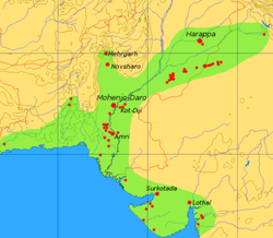
The Indus Valley Civilization (IVC) was a Bronze Age civilization (3300–1300 BCE; mature period 2600–1900 BCE) extending from what today is northeast Afghanistan to Pakistan and northwest India (see map).[1] Along with Ancient Egypt andMesopotamia it was one of three early civilizations of the Old World, and of the three the most widespread.[2] It flourished in the basins of the Indus River, one of the major rivers of Asia, and the Ghaggar-Hakra River, which once coursed through northwest India and eastern Pakistan.[3]
At its peak, the Indus Civilization may have had a population of over five million. Inhabitants of the ancient Indus river valley developed new techniques in handicraft (carnelian products, seal carving) and metallurgy (copper, bronze, lead, and tin). The Indus cities are noted for their urban planning, baked brick houses, elaborate drainage systems, water supply systems, and clusters of large non-residential buildings.[4]
The Indus Valley Civilization is also known as the Harappan Civilization, after Harappa, the first of its sites to be excavated in the 1920s, in what was then the Punjab province of British India, and now is Pakistan.[5] The discovery of Harappa, and soon afterwards, Mohenjo-Daro, was the culmination of work beginning in 1861 with the founding of the Archaeological Survey of Indiain the British Raj.[6] Excavation of Harappan sites has been ongoing since 1920, with important breakthroughs occurring as recently as 1999.[7] There were earlier and later cultures, often called Early Harappan and Late Harappan, in the same area of the Harappan Civilization. The Harappan civilisation is sometimes called the Mature Harappan culture to distinguish it from these cultures. Until 1999, over 1,056 cities and settlements had been found, of which 96 have been excavated,[8] mainly in the general region of the Indus and Ghaggar-Hakra Rivers and their tributaries. Among the settlements were the major urban centres ofHarappa, Mohenjo-daro (UNESCO World Heritage Site), Dholavira, Ganeriwala in Cholistan and Rakhigarhi.[9]
The Harappan language is not directly attested and its affiliation is uncertain since the Indus script is still undeciphered. A relationship with the Dravidian or Elamo-Dravidian language family is favored by a section of scholars.[10]

Discovery and excavation
The ruins of Harrappa were first described in 1842 by Charles Masson in his Narrative of Various Journeys in Balochistan, Afghanistan, and the Punjab, where locals talked of an ancient city extending "thirteen cosses" (about 25 miles), but no archaeological interest would attach to this for nearly a century.[12]
In 1856, General Alexander Cunningham, later director general of the archeological survey of northern India, visited Harappa where the British engineers John and William Brunton were laying the East Indian Railway Company line connecting the cities of Karachi and Lahore. John wrote: "I was much exercised in my mind how we were to get ballast for the line of the railway". They were told of an ancient ruined city near the lines, called Brahminabad. Visiting the city, he found it full of hard well-burnt bricks, and, "convinced that there was a grand quarry for the ballast I wanted", the city of Brahminabad was reduced to ballast.[13] A few months later, further north, John's brother William Brunton's "section of the line ran near another ruined city, bricks from which had already been used by villagers in the nearby village of Harappa at the same site. These bricks now provided ballast along 93 miles (150 km) of the railroad track running from Karachi to Lahore".[13]In 1872–75 Alexander Cunningham published the first Harappan seal (with an erroneous identification as Brahmi letters).[14] It was half a century later, in 1912, that more Harappan seals were discovered by J. Fleet, prompting an excavation campaign under Sir John Hubert Marshall in 1921–22 and resulting in the discovery of the civilization at Harappa by Sir John Marshall, Rai Bahadur Daya Ram Sahni and Madho Sarup Vats, and at Mohenjo-daro by Rakhal Das Banerjee, E. J. H. MacKay, and Sir John Marshall. By 1931, much of Mohenjo-Daro had been excavated, but excavations continued, such as that led by Sir Mortimer Wheeler, director of the Archaeological Survey of India in 1944. Among other archaeologists who worked on IVC sites before the partition of the subcontinent in 1947 were Ahmad Hasan Dani, Brij Basi Lal, Nani Gopal Majumdar, and Sir Marc Aurel Stein.
Following the Partition of India, the bulk of the archaeological finds were inherited by Pakistan where most of the IVC was based, and excavations from this time include those led by Sir Mortimer Wheeler in 1949, archaeological adviser to the Government of Pakistan. Outposts of the Indus Valley civilization were excavated as far west asSutkagan Dor in Baluchistan, as far north as at Shortugai on the Amu Darya (the river's ancient name was Oxus) in current Afghanistan, as far east as at Alamgirpur, Uttar Pradesh, India and as far south as at Malwan, Surat Dist., India.[15]

Chronology
The mature phase of the Harappan civilization lasted from c. 2600 to 1900 BCE. With the inclusion of the predecessor and successor cultures—Early Harappan and Late Harappan, respectively—the entire Indus Valley Civilization may be taken to have lasted from the 33rd to the 14th centuries BCE. Two terms are employed for the periodization of the IVC: Phases and Eras.[16][17] The Early Harappan, Mature Harappan, and Late Harappan phases are also called the Regionalisation, Integration, and Localisation eras, respectively, with the Regionalization era reaching back to the Neolithic Mehrgarh II period. "Discoveries at Mehrgarh changed the entire concept of the Indus civilization", according to Ahmad Hasan Dani, professor emeritus at Quaid-e-Azam University, Islamabad. "There we have the whole sequence, right from the beginning of settled village life."[18]
| Dates | Phase | Era |
|---|---|---|
| 7000–5500 BCE | Mehrgarh I (aceramic Neolithic) | Early Food-Producing Era |
| 5500–3300 | Mehrgarh II-VI (ceramic Neolithic) | Regionalisation Era |
| 3300–2600 | Early Harappan | |
| 3300–2800 | Harappan 1 (Ravi Phase) | |
| 2800–2600 | Harappan 2 (Kot Diji Phase, Nausharo I, Mehrgarh VII) | |
| 2600–1900 | Mature Harappan (Indus Valley Civilization) | Integration Era |
| 2600–2450 | Harappan 3A (Nausharo II) | |
| 2450–2200 | Harappan 3B | |
| 2200–1900 | Harappan 3C | |
| 1900–1300 | Late Harappan (Cemetery H); Ochre Coloured Pottery | Localisation Era |
| 1900–1700 | Harappan 4 | |
| 1700–1300 | Harappan 5 | |
| 1300–300 | Painted Gray Ware, Northern Black Polished Ware (Iron Age) | Indo-Gangetic Tradition |
Geography
The Indus Valley Civilization encompassed most of Pakistan and parts of northwestern India, Afghanistan and Iran, extending from Balochistan in the west to Uttar Pradesh in the east, northeastern Afghanistan to the north and Maharashtra to the south.[19] The geography of the Indus Valley put the civilizations that arose there in a highly similar situation to those in Egypt andPeru, with rich agricultural lands being surrounded by highlands, desert, and ocean. Recently, Indus sites have been discovered in Pakistan's northwestern Frontier Province as well. Other IVC colonies can be found in Afghanistan while smaller isolated colonies can be found as far away as Turkmenistan and in Gujarat. Coastal settlements extended from Sutkagan Dor[20] in Western Baluchistan to Lothal[21] in Gujarat. An Indus Valley site has been found on the Oxus River at Shortughai in northern Afghanistan,[22] in the Gomal River valley in northwestern Pakistan,[23] atManda,Jammu on the Beas River near Jammu,[24] India, and at Alamgirpur on the Hindon River, only 28 km from Delhi.[25] Indus Valley sites have been found most often on rivers, but also on the ancient seacoast,[26] for example, Balakot,[27] and on islands, for example, Dholavira.[28]
There is evidence of dry river beds overlapping with the Hakra channel in Pakistan and the seasonal Ghaggar River in India. Many Indus Valley (or Harappan) sites have been discovered along the Ghaggar-Hakra beds.[29] Among them are: Rupar, Rakhigarhi, Sothi, Kalibangan, and Ganwariwala.[30] According to J. G. Shaffer and D. A. Lichtenstein,[31] the Harappan Civilization "is a fusion of the Bagor, Hakra, and Koti Dij traditions or 'ethnic groups' in the Ghaggar-Hakra valley on the borders of India and Pakistan".[29]
According to some archaeologists, more than 500 Harappan sites have been discovered along the dried up river beds of the Ghaggar-Hakra River and its tributaries,[32] in contrast to only about 100 along the Indus and its tributaries;[33] consequently, in their opinion, the appellation Indus Ghaggar-Hakra civilisation or Indus-Saraswati civilisation is justified. However, these politically inspired arguments are disputed by other archaeologists who state that the Ghaggar-Hakra desert area has been left untouched by settlements and agriculture since the end of the Indus period and hence shows more sites than found in the alluvium of the Indus valley; second, that the number of Harappan sites along the Ghaggar-Hakra river beds have been exaggerated and that the Ghaggar-Hakra, when it existed, was a tributary of the Indus, so the new nomenclature is redundant.[34] "Harappan Civilization" remains the correct one, according to the common archaeological usage of naming a civilization after its first findspot.
Early Harappan
The Early Harappan Ravi Phase, named after the nearby Ravi River, lasted from circa 3300 BCE until 2800 BCE. It is related to the Hakra Phase, identified in the Ghaggar-Hakra River Valley to the west, and predates the Kot Diji Phase (2800-2600 BCE, Harappan 2), named after a site in northern Sindh, Pakistan, near Mohenjo Daro. The earliest examples of the Indus script date from around 3000 BCE.[35]
The mature phase of earlier village cultures is represented by Rehman Dheri and Amri in Pakistan.[36] Kot Diji (Harappan 2) represents the phase leading up to Mature Harappan, with the citadel representing centralised authority and an increasingly urban quality of life. Another town of this stage was found at Kalibangan in India on the Hakra River.[37]
Trade networks linked this culture with related regional cultures and distant sources of raw materials, including lapis lazuli and other materials for bead-making. Villagers had, by this time, domesticated numerous crops, including peas, sesame seeds, dates, and cotton, as well as animals, including the water buffalo. Early Harappan communities turned to large urban centres by 2600 BCE, from where the mature Harappan phase started.
Mature Harappan
By 2600 BCE, the Early Harappan communities had been turned into large urban centres. Such urban centres include Harappa, Ganeriwala, Mohenjo-Daro in modern day Pakistan, and Dholavira,Kalibangan, Rakhigarhi, Rupar, and Lothal in modern day India. In total, more than 1,052 cities and settlements have been found, mainly in the general region of the Indus Rivers and their tributaries.

Cities
A sophisticated and technologically advanced urban culture is evident in the Indus Valley Civilization making them the first urban centres in the region. The quality of municipal town planning suggests the knowledge of urban planning and efficient municipal governments which placed a high priority onhygiene, or, alternatively, accessibility to the means of religious ritual.
As seen in Harappa, Mohenjo-Daro and the recently partially excavated Rakhigarhi, this urban plan included the world's first known urban sanitationsystems: see hydraulic engineering of the Indus Valley Civilization. Within the city, individual homes or groups of homes obtained water from wells. From a room that appears to have been set aside for bathing, waste water was directed to covered drains, which lined the major streets. Houses opened only to inner courtyards and smaller lanes. The house-building in some villages in the region still resembles in some respects the house-building of the Harappans.[38]
The ancient Indus systems of sewerage and drainage that were developed and used in cities throughout the Indus region were far more advanced than any found in contemporary urban sites in the Middle East and even more efficient than those in many areas of Pakistan and India today. The advanced architecture of the Harappans is shown by their impressive dockyards, granaries, warehouses, brick platforms, and protective walls. The massive walls of Indus cities most likely protected the Harappans from floods and may have dissuaded military conflicts.[citation needed]
The purpose of the citadel remains debated. In sharp contrast to this civilization's contemporaries, Mesopotamia and Ancient Egypt, no large monumental structures were built. There is no conclusive evidence of palaces or temples—or of kings, armies, or priests. Some structures are thought to have been granaries. Found at one city is an enormous well-built bath (the "Great Bath"), which may have been a public bath. Although the citadels were walled, it is far from clear that these structures were defensive. They may have been built to divert flood waters.
Most city dwellers appear to have been traders or artisans, who lived with others pursuing the same occupation in well-defined neighbourhoods. Materials from distant regions were used in the cities for constructing seals, beads and other objects. Among the artifacts discovered were beautiful glazed faïencebeads. Steatite seals have images of animals, people (perhaps gods), and other types of inscriptions, including the yet un-deciphered writing system of the Indus Valley Civilization. Some of the seals were used to stamp clay on trade goods and most probably had other uses as well.
Although some houses were larger than others, Indus Civilization cities were remarkable for their apparent, if relative, egalitarianism. All the houses had access to water and drainage facilities. This gives the impression of a society with relatively low wealth concentration, though clear social levelling is seen in personal adornments.
Authority and governance
Archaeological records provide no immediate answers for a center of power or for depictions of people in power in Harappan society. But, there are indications of complex decisions being taken and implemented. For instance, the extraordinary uniformity of Harappan artifacts as evident in pottery, seals, weights and bricks. These are the major assumptions:
- There was a single state, given the similarity in artifacts, the evidence for planned settlements, the standardised ratio of brick size, and the establishment of settlements near sources of raw material.
- There was no single ruler but several: Mohenjo-daro had a separate ruler, Harappa another, and so forth.
- Harappan society had no rulers, and everybody enjoyed equal status.
Technology
The people of the Indus Civilization achieved great accuracy in measuring length, mass, and time. They were among the first to develop a system of uniform weights and measures. A comparison of available objects indicates large scale variation across the Indus territories. Their smallest division, which is marked on an ivory scale found in Lothal, was approximately 1.704 mm, the smallest division ever recorded on a scale of the Bronze Age. Harappan engineers followed the decimal division of measurement for all practical purposes, including the measurement of mass as revealed by theirhexahedron weights.[39]
These chert weights were in a ratio of 5:2:1 with weights of 0.05, 0.1, 0.2, 0.5, 1, 2, 5, 10, 20, 50, 100, 200, and 500 units, with each unit weighing approximately 28 grams, similar to the English Imperial ounce or Greek uncia, and smaller objects were weighed in similar ratios with the units of 0.871. However, as in other cultures, actual weights were not uniform throughout the area. The weights and measures later used in Kautilya's Arthashastra (4th century BCE) are the same as those used in Lothal.[40]
Harappans evolved some new techniques in metallurgy and produced copper, bronze, lead, and tin. The engineering skill of the Harappans was remarkable, especially in building docks.
In 2001, archaeologists studying the remains of two men from Mehrgarh, Pakistan, made the discovery that the people of the Indus Valley Civilization, from the early Harappan periods, had knowledge of proto-dentistry. Later, in April 2006, it was announced in the scientific journal Nature that the oldest (and first early Neolithic) evidence for the drilling of human teeth in vivo (i.e., in a living person) was found in Mehrgarh. Eleven drilled molar crowns from nine adults were discovered in a Neolithic graveyard in Mehrgarh that dates from 7,500-9,000 years ago. According to the authors, their discoveries point to a tradition of proto-dentistry in the early farming cultures of that region.[41]
A touchstone bearing gold streaks was found in Banawali, which was probably used for testing the purity of gold (such a technique is still used in some parts of India).[42]

Arts and crafts
Various sculptures, seals, pottery, gold jewelry, and anatomically detailed figurines in terracotta, bronze, and steatite have been found at excavation sites.
A number of gold, terra-cotta and stone figurines of girls in dancing poses reveal the presence of some dance form. Also, these terra-cotta figurines included cows, bears, monkeys, and dogs. The animal depicted on a majority of seals at sites of the mature period has not been clearly identified. Part bull, part zebra, with a majestic horn, it has been a source of speculation. As yet, there is insufficient evidence to substantiate claims that the image had religious or cultic significance, but the prevalence of the image raises the question of whether or not the animals in images of the IVC are religious symbols.[43]
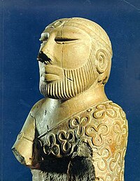
Sir John Marshall is known to have reacted with surprise when he saw the famous Indus bronze statuette of a slender-limbed dancing girl in Mohenjo-Daro:
When I first saw them I found it difficult to believe that they were prehistoric; they seemed to completely upset all established ideas about early art, and culture. Modeling such as this was unknown in the ancient world up to the Hellenistic age of Greece, and I thought, therefore, that some mistake must surely have been made; that these figures had found their way into levels some 3000 years older than those to which they properly belonged .... Now, in these statuettes, it is just this anatomical truth which is so startling; that makes us wonder whether, in this all-important matter, Greek artistry could possibly have been anticipated by the sculptors of a far-off age on the banks of the Indus.

Many crafts "such as shell working, ceramics, and agate and glazed steatite bead making" were used in the making of necklaces, bangles, and other ornaments from all phases of Harappan sites and some of these crafts are still practised in the subcontinent today.[44] Some make-up and toiletry items (a special kind of combs (kakai), the use of collyrium and a special three-in-one toiletry gadget) that were found in Harappan contexts still have similar counterparts in modern India.[45] Terracotta female figurines were found (ca. 2800-2600 BCE) which had red colour applied to the "manga" (line of partition of the hair).[45]
Seals have been found at Mohenjo-Daro depicting a figure standing on its head, and another sitting cross-legged in what some call a yoga-like pose (see image, the so-called Pashupati, below).
This figure, sometimes known as a Pashupati, has been variously identified. Sir John Marshall identified a resemblance to the Hindu god, Shiva.[46] If this can be validated, it would be evidence that some aspects of Hinduism predate the earliest texts, the Veda.
A harp-like instrument depicted on an Indus seal and two shell objects found at Lothal indicate the use of stringed musical instruments. The Harappans also made various toys and games, among them cubical dice (with one to six holes on the faces), which were found in sites like Mohenjo-Daro.[47]

Trade and transportation
The Indus civilization's economy appears to have depended significantly on trade, which was facilitated by major advances in transport technology. The IVC may have been the first civilization to use wheeled transport.[48] These advances may have included bullock carts that are identical to those seen throughout South Asia today, as well as boats. Most of these boats were probably small, flat-bottomed craft, perhaps driven by sail, similar to those one can see on the Indus River today; however, there is secondary evidence of seagoing craft. Archaeologists have discovered a massive, dredged canal and what they regard as a docking facility at the coastal city of Lothal in western India (Gujarat state). An extensive canal network, used for irrigation, has however also been discovered by H.-P. Francfort.
During 4300–3200 BCE of the chalcolithic period (copper age), the Indus Valley Civilization area shows ceramic similarities with southern Turkmenistan and northernIran which suggest considerable mobility and trade. During the Early Harappan period (about 3200–2600 BCE), similarities in pottery, seals, figurines, ornaments, etc. document intensive caravan trade with Central Asia and the Iranian plateau.[49]
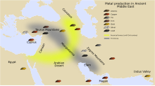
Judging from the dispersal of Indus civilization artifacts, the trade networks, economically, integrated a huge area, including portions of Afghanistan, the coastal regions of Persia, northern and western India, and Mesopotamia.
There is some evidence that trade contacts extended to Crete and possibly to Egypt.[50]
There was an extensive maritime trade network operating between the Harappan and Mesopotamian civilizations as early as the middle Harappan Phase, with much commerce being handled by "middlemen merchants from Dilmun" (modern Bahrain and Failakalocated in the Persian Gulf).[51] Such long-distance sea trade became feasible with the innovative development of plank-built watercraft, equipped with a single central mast supporting a sail of woven rushes or cloth.
Several coastal settlements like Sotkagen-dor (astride Dasht River, north of Jiwani), Sokhta Koh (astride Shadi River, north of Pasni), and Balakot (near Sonmiani) in Pakistan along with Lothal in India testify to their role as Harappan trading outposts. Shallow harbors located at the estuaries of rivers opening into the sea allowed brisk maritime trade with Mesopotamian cities.

Subsistence
Some post-1980 studies indicate that food production was largely indigenous to the Indus Valley. It is known that the people of Mehrgarh used domesticated wheats and barley,[52] and the major cultivated cereal crop was naked six-row barley, a crop derived from two-row barley (see Shaffer and Liechtenstein 1995, 1999). Archaeologist Jim G. Shaffer (1999: 245) writes that the Mehrgarh site "demonstrates that food production was an indigenous South Asian phenomenon" and that the data support interpretation of "the prehistoric urbanization and complex social organization in South Asia as based on indigenous, but not isolated, cultural developments". Others, such as Dorian Fuller, however, indicate that it took some 2000 years before Middle Eastern wheat was acclimatised to South Asian conditions.
Writing system
Between 400 and as many as 600 distinct Indus symbols[53] have been found on seals, small tablets, ceramic pots and more than a dozen other materials, including a "signboard" that apparently once hung over the gate of the inner citadel of the Indus city of Dholavira.

Typical Indus inscriptions are no more than four or five characters in length, most of which (aside from the Dholavira "signboard") are tiny; the longest on a single surface, which is less than 1 inch (2.54 cm) square, is 17 signs long; the longest on any object (found on three different faces of a mass-produced object) has a length of 26 symbols.
While the Indus Valley Civilization is generally characterized as a literate society on the evidence of these inscriptions, this description has been challenged by Farmer, Sproat, and Witzel (2004)[54] who argue that the Indus system did not encode language, but was instead similar to a variety of non-linguistic sign systems used extensively in the Near East and other societies. Others have claimed on occasion that the symbols were exclusively used for economic transactions, but this claim leaves unexplained the appearance of Indus symbols on many ritual objects, many of which were mass-produced inmoulds. No parallels to these mass-produced inscriptions are known in any other early ancient civilizations.[55]
In a 2009 study by P. N. Rao et al. published in Science, computer scientists, comparing the pattern of symbols to various linguistic scripts and non-linguistic systems, including DNA and a computer programming language, found that the Indus script's pattern is closer to that of spoken words, supporting the hypothesis that it codes for an as-yet-unknown language.[56][57]
Farmer, Sproat, and Witzel have disputed this finding, pointing out that Rao et al. did not actually compare the Indus signs with "real-world non-linguistic systems" but rather with "two wholly artificial systems invented by the authors, one consisting of 200,000 randomly ordered signs and another of 200,000 fully ordered signs, that they spuriously claim represent the structures of all real-world non-linguistic sign systems".[58] Farmer et al. have also demonstrated that a comparison of a non-linguistic system like medieval heraldic signs with natural languages yields results similar to those that Rao et al. obtained with Indus signs. They conclude that the method used by Rao et al. cannot distinguish linguistic systems from non-linguistic ones.[59]
The messages on the seals have proved to be too short to be decoded by a computer. Each seal has a distinctive combination of symbols and there are too few examples of each sequence to provide a sufficient context. The symbols that accompany the images vary from seal to seal, making it impossible to derive a meaning for the symbols from the images. There have, nonetheless, been a number of interpretations offered for the meaning of the seals. These interpretations have been marked by ambiguity and subjectivity.[59]:69
Photos of many of the thousands of extant inscriptions are published in the Corpus of Indus Seals and Inscriptions (1987, 1991, 2010), edited by Asko Parpola and his colleagues. The final, third, volume, republished photos taken in the 1920s and 1930s of hundreds of lost or stolen inscriptions, along with many discovered in the last few decades. Formerly, researchers had to supplement the materials in the Corpus by study of the tiny photos in the excavation reports of Marshall (1931), MacKay (1938, 1943), Wheeler (1947), or reproductions in more recent scattered sources.
Religion
Some Indus valley seals show swastikas, which are found in other religions worldwide, especially in Indian religions such as Hinduism, Buddhism, andJainism. The earliest evidence for elements of Hinduism are alleged to have been present before and during the early Harappan period.[60] Phallic symbols interpreted as the much later Hindu Shiva lingam have been found in the Harappan remains.[61][62]
Many Indus valley seals show animals. One seal shows a horned figure seated in a posture reminiscent of the Lotus position and surrounded by animals was named by early excavators Pashupati (lord of cattle), an epithet of the later Hindu gods Shiva and Rudra.[63][64][65] Writing in 1997 Doris Srinivasansaid that "Not too many recent studies continue to call the seal's figure a "Proto-Siva," rejecting thereby Marshall's package of proto-Siva features, including that of three heads. She interprets what John Marshall interpreted as facial as not human but more bovine, possibly a divine buffalo-man.[66]According toIravatham Mahadevan symbols 47 and 48 of his Indus script glossary The Indus Script: Texts, Concordance and Tables (1977), representing seated human-like figures, could describe Hindu deity Murugan.[67]

According to Rita P. Wright:
Several lines of evidence have been used to identify depictions of gods, goddesses , and animals as symbols of practices known from historic South Asian religions, principally Buddhism and Hinduism. The figurines and narratives depicted on seals continue to be central to arguments for and against these interpretations. Their direct relationship to modern South Asian religions remains ambiguous in view of the great time depth between the last vestiges of the Indus civilization and the emergence of Hinduism and Buddhism in the mid to late first millennium B. C. Even if later religions were to have borrowed and/or revived imagery from the Indus culture, the meanings attached to them are unlikely to have remained the same, since meanings inherent in borrowed images typically are transformed in a new cultural context.[68]
There are no religious buildings or evidence of elaborate burials. If there were temples, they have not been identified.[69] However, House - 1 in HR-A area in Mohenjadaro's Lower Town has been identified as a possible temple.[70]
In the earlier phases of their culture, the Harappans buried their dead; however, later, especially in the Cemetery H culture of the late Harrapan period, they also cremated their dead and buried the ashes in burial urns.
It is possible that a temple exists to the East of the great bath, but the site has not been excavated. There is a Buddhist reliquary mound on the site and permission has not been granted to move it.[71] Until there is sufficient evidence, speculation about the religion of the IVC is largely based on a retrospective view from a much later Hindu perspective.[43

Collapse and Late Harappan
Main article: Late Harappan
Around 1800 BCE, signs of a gradual decline began to emerge, and by around 1700 BCE, most of the cities were abandoned. In 1953, Sir Mortimer Wheeler proposed that the decline of the Indus Civilization was caused by the invasion of an Indo-European tribe from Central Asia called the "Aryans". As evidence, he cited a group of 37 skeletons found in various parts of Mohenjo-Daro, and passages in the Vedas referring to battles and forts. However, scholars soon started to reject Wheeler's theory, since the skeletons belonged to a period after the city's abandonment and none were found near the citadel. Subsequent examinations of the skeletons by Kenneth Kennedy in 1994 showed that the marks on the skulls were caused by erosion, and not violent aggression.[72]Today, many scholars believe that the collapse of the Indus Civilization was caused by drought and a decline in trade with Egypt and Mesopotamia.[73] It has also been suggested that immigration by new peoples, deforestation, floods, or changes in the course of the river may have contributed to the collapse of the IVC.[74]
Previously, it was also believed that the decline of the Harappan civilization led to an interruption of urban life in the Indian subcontinent. However, the Indus Valley Civilization did not disappear suddenly, and many elements of the Indus Civilization can be found in later cultures. Current archaeological data suggest that material culture classified as Late Harappan may have persisted until at least c. 1000-900 BCE and was partially contemporaneous with the Painted Grey Ware culture.[75] Harvard archaeologist Richard Meadow points to the late Harappan settlement of Pirak, which thrived continuously from 1800 BCE to the time of the invasion of Alexander the Great in 325 BCE.[73]
Recent archaeological excavations indicate that the decline of Harappa drove people eastward. After 1900 BCE, the number of sites in India increased from 218 to 853. Excavations in the Gangetic plain show that urban settlement began around 1200 BCE, only a few centuries after the decline of Harappa and much earlier than previously expected.[73] Archaeologists have emphasized that, just as in most areas of the world, there was a continuous series of cultural developments. These link "the so-called two major phases of urbanization in South Asia".[75]
A possible natural reason for the IVC's decline is connected with climate change that is also signalled for the neighbouring areas of the Middle East: The Indus valley climate grew significantly cooler and drier from about 1800 BCE, linked to a general weakening of the monsoon at that time. Alternatively, a crucial factor may have been the disappearance of substantial portions of the Ghaggar Hakra river system. A tectonic event may have diverted the system's sources toward the Ganges Plain, though there is complete uncertainty about the date of this event, as most settlements inside Ghaggar-Hakra river beds have not yet been dated. The actual reason for decline might be any combination of these factors. New geological research is now being conducted by a group led by Peter Clift, from the University of Aberdeen, to investigate how the courses of rivers have changed in this region since 8000 years ago, to test whether climate or river reorganizations are responsible for the decline of the Harappan. A 2004 paper indicated that the isotopes of the Ghaggar-Hakra system do not come from the Himalayan glaciers, and were rain-fed instead, contradicting a Harappan time mighty "Sarasvati" river.[76]
A research team led by the geologist Liviu Giosan of the Woods Hole Oceanographic Institution also concluded that climate change in form of the easterward migration of the monsoons led to the decline of the IVC.[77] The team's findings were published in PNAS in May 2012.[78][79] According to their theory, the slow eastward migration of the monsoons across Asia initially allowed the civilization to develop. The monsoon-supported farming led to large agricultural surpluses, which in turn supported the development of cities. The IVC residents did not develop irrigation capabilities, relying mainly on the seasonal monsoons. As the monsoons kept shifting eastward, the water supply for the agricultural activities dried up. The residents then migrated towards the Ganges basin in the east, where they established smaller villages and isolated farms. The small surplus produced in these small communities did not allow development of trade, and the cities died out.[80]
Legacy
Main article: Iron Age India
In the aftermath of the Indus Civilization's collapse, regional cultures emerged, to varying degrees showing the influence of the Indus Civilization. In the formerly great city of Harappa, burials have been found that correspond to a regional culture called the Cemetery H culture. At the same time, the Ochre Coloured Pottery culture expanded from Rajasthan into the Gangetic Plain. The Cemetery H culture has the earliest evidence for cremation; a practice dominant in Hinduism today.
Historical context and linguistic affiliation
See also: Substratum in Vedic Sanskrit
The IVC has been tentatively identified with the toponym Meluhha known from Sumerian records. It has been compared in particular with the civilizations of Elam (also in the context of the Elamo-Dravidian hypothesis) and with Minoan Crete (because of isolated cultural parallels such as the ubiquitous goddess worship and depictions of bull-leaping).[81] The mature (Harappan) phase of the IVC is contemporary to the Early to Middle Bronze Age in the Ancient Near East, in particular the Old Elamite period, Early Dynastic to Ur III Mesopotamia, Prepalatial Minoan Crete and Old Kingdom to First Intermediate Period Egypt.
After the discovery of the IVC in the 1920s, it was immediately associated with the indigenous Dasyu inimical to the Rigvedic tribes in numerous hymns of the Rigveda. Mortimer Wheelerinterpreted the presence of many unburied corpses found in the top levels of Mohenjo-Daro as the victims of a warlike conquest, and famously stated that "Indra stands accused" of the destruction of the IVC. The association of the IVC with the city-dwelling Dasyus remains alluring because the assumed timeframe of the first Indo-Aryan migration into India corresponds neatly with the period of decline of the IVC seen in the archaeological record. The discovery of the advanced, urban IVC however changed the 19th-century view of early Indo-Aryan migration as an "invasion" of an advanced culture at the expense of a "primitive" aboriginal population to a gradual acculturation of nomadic "barbarians" on an advanced urban civilization, comparable to the Germanic migrations after the Fall of Rome, or the Kassite invasion of Babylonia. This move away from simplistic "invasionist" scenarios parallels similar developments in thinking about language transfer and population movement in general, such as in the case of the migration of the proto-Greek speakers into Greece, or the Indo-Europeanization of Western Europe.
It was often suggested that the bearers of the IVC corresponded to proto-Dravidians linguistically, the breakup of proto-Dravidian corresponding to the breakup of the Late Harappan culture.[82]Today, the Dravidian language family is concentrated mostly in southern India and northern Sri Lanka, but pockets of it still remain throughout the rest of India and Pakistan (the Brahui language), which lends credence to the theory. Finnish Indologist Asko Parpola concludes that the uniformity of the Indus inscriptions precludes any possibility of widely different languages being used, and that an early form of Dravidian language must have been the language of the Indus people. However, in an interview with the Deccan Herald on 12 August 2012, Asko Parpola clarified his position by admitting that Sanskrit-speakers had contributed to the Indus Valley Civilization.[83] Proto-Munda (or Para-Munda) and a "lost phylum" (perhaps related or ancestral to the Nihali language)[84]have been proposed as other candidates.
The civilization is sometimes referred to as the Indus Ghaggar-Hakra civilization or Indus-Sarasvati civilization by Hindutva groups.[85] or the Indus-Sarasvati civilization.[86][87]
Developments in July 2010
Main article: 2010 Pakistan floods
On 11 July, heavy floods hit Haryana in India and damaged the archaeological site of Jognakhera, where ancient copper smelting were found dating back almost 5,000 years. The Indus Valley Civilization site was hit by almost 10 feet of water as the Sutlej Yamuna link canal overflowed.[88]
Your post is very great.I read this post. It’s very helpful. You can check more about Adapalene and Benzoyl Peroxide manufacturer here
TumugonBurahin